Field trips guides are now available. Please download the
Wednesday, Saturday and
Sunday field trip guides.
Weather in October can range from 0-8°C/33-46°F. Rain and snow are possible. Attendees should plan to wear clothing suitable for this type of weather. Please consider wind/rainproof outerwear, a thermal base layer, a hat and scarf, shoes for hiking, a water bottle, and a small backpack.
Wednesday AfternoonWednesday afternoon will be a half day field trip for all conference participants to the western rift zone. Attendees will depart the Hotel Selfoss at noon with a boxed lunch to enjoy on the bus. The field trip will travel to Nesjavellir, Þingvellir, and Geysir and will focus on slow rifting, tectonic and geothermal processes. A group dinner will be held at 7:00 PM. The buses will return attendees to the Hotel Selfoss at approximately 9:00 PM. Attendee registration includes this field trip.
Nesjavellir geothermal power station is situated in one of the major geothermal areas in Iceland. It is located within the 60 km long Hengill volcanic system at the intersection of the Reykjanes Peninsula, the Western Volcanic Zone and the South Iceland Seismic Zone. Volcano-tectonic faulting is prominent. The Hengill volcanic system has been moderately active with nine volcanic eruptions in the Holocene. The last two eruptions, about 1900 and 5800 years ago, took place on 27 and 20 km long fissures and each of their lavas are about 30 km2. The youngest eruption fissure extended into Lake Þingvallavatn where phreatomagmatic activity created a tephra ring island, Sandey. The Hengill region is seismically active, with over 25000 detected events during an inflation period from 1994 to 1999.
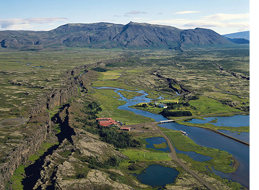 Þingvellir is a shallow rift valley, that forms part of the Hengill volcanic system. The rift valley is 50-70 m deep and 6-10 km across. The last major rifting episode occurred in 1789, where the margin subsided by 1,2 meters and the center up to 2,6 meters. The Þingvellir rift valley is covered by early Holocene lava flows. A sequence of thin compound lavaflows can be viewed in cross section in the fault scarps, including chilled contacts and columnar jointing. To the north the Skjaldbreiður shield volcano can be seen. It was formed in a single prolonged eruption about 10.000 years ago. Þingvellir is considered as the cradle of democracy, as this is where the first Icelandic parliament was founded in 930 CE. It was named a UNESCO World Heritage Site in 1972.
 The Geysir area is a geothermal area with fumaroles, boiling mud and actively erupting hot-springs. The English word "geyser" is derived from the Icelandic word "geysir" which means gusher. Though the Great Geysir itself is now more or less inactive since 1916, the area surrounding it is geothermally very active with many smaller hot springs. The attraction of the area is now Strokkur (The Churn), another geyser 100 meters south of the Great Geysir, which erupts at regular intervals every 5-10 minutes. Its white column of boiling water can reach as high as 30 meters. The whole area is a geothermal park sitting on top of a vast boiling cauldron. Belching sulphurous mud pots of unusual colors, hissing steam vents, hot and cold springs, warm streams, and primitive plants can all be found here.
Optional Post-Conference Field TripsAttendees have the option to attend a two-day field trip following the conference. The optional field trip will be on Saturday, 19 October and Sunday, 20 October. Saturday will begin and end at the Hotel Selfoss. Sunday, all guests will check out of the Hotel Selfoss with the final stop in Reykjavik.
Cost: $425.00 USD per person
Deadline to Register: 4 September
A minimum of 25 attendees are required for the post-conference field trip to be held. Should the minimum number of attendees fall short, the field trip fees will be refunded.
Date: Saturday, 19 October
Depart: 8:00 AM from the Hotel Selfoss
Return: 9:00 PM (approximately) to the Hotel Selfoss
Details: The field trip will take the group to the eastern rift zone along the Ring Road. A boxed lunch and group dinner n Kirkubærklaustur are planned.
Areas: SISZ, Eastern Volcanic Zone (incl. Hekla, Eyjafjallajökull, Katla, Eldgjá, Laki)
Scientific focus: Bookshelf faulting, central volcanoes, large rifting events
We will start by crossing the South Iceland Seismic Zone (SISZ), the immature E-W trending left-lateral transform zone that connects the Western and Eastern Volcanic zones. The SISZ extends about 70-80 km E-W and 10-15 km N-S. Although the zone trends E-W and has a left-lateral sense of shear, earthquakes occur along N-S striking, right-lateral strike slip faults, a phenomenon known as bookshelf tectonics. Historical records going back 1100 years show that earthquakes in the SISZ tend to cluster in time. More than 30 destructive earthquakes in the area have been documented since 1164 AD, either as single events, or more commonly as sequences of two or more magnitude 6 to 7 earthquakes over a period of days to a few years. These earthquake sequences have recurred every 45 to 112 years. Succeeding the SISZ, we will focus on the many large central volcanoes located in south Iceland, and furthermore have a look at the products of some of the large rifting events from the Eastern Volcanic Zone.
 The Hekla volcanic system has been highly active in the Holocene. The last eruption occurred in 2000 CE and it is the third most active in Iceland in the last millennium with 23 eruptions (VEI 0-5). The Hekla system belongs to the Eastern Volcanic Zone and consists of a central volcano rising to 1490 m a.s.l. and an about 60 km long fissure swarm. Eruption frequency is highest at the Hekla central volcano, which typically produces mixed eruptions with tephra and lava of silicic to intermediate composition. They feature a short plinian or subplinian opening phase (VEI 2-4) followed by lava effusion. The preceding repose commands the SiO2 content of the first erupted magma (the magnitude of the opening phase) and the volumes erupted - the shorter the repose the smaller the following eruption. About 100 eruptions are known in the last 9000 years, ranging from purely explosive to purely effusive. The largest explosive eruptions (VEI 6) occurred 4300 and 3000 years ago. (from http://icelandicvolcanos.is/?volcano=HEK)
The Eyjafjallajökull volcanic system has been moderately active in the Holocene (last 8000 years). The last eruption occurred in 2010 CE producing 0.27 km3 of tephra and 0.023 km3 of lava. Located on the Eastern Volcanic Zone, it is an east-west elongated central volcano about 25 km long and 15 km wide, rising to 1651 m a.s.l. It is partly covered by up to 200 m thick ice and has a 2.5 km wide, ice-filled summit caldera. The characteristic activity is explosive intermediate to silicic eruptions with tephra volumes (bulk volume) ranging from 0.01 to 0.27 km3 and small basaltic and intermediate lava flows. The average interval between eruptions during the last 1500 years is 350-400 years. Eruptions are accompanied by jökulhlaups. (from http://icelandicvolcanos.is/?volcano=EYJ)
The partly ice covered Katla volcanic system has been highly active in the Holocene with at least 21 eruptions in the last 1100 years. The last eruption to break through the ice took place in 1918 CE. The Katla system is about 80 km long, consisting of a central volcano rising to 1500 m a.s.l. and an active fissure swarm extending towards northeast. The central volcano is partly covered by up to 700 m thick ice and has an 9x14 km ice-filled caldera.
The characteristic activity is explosive basaltic eruptions at the Katla central volcano with tephra volumes (bulk volume) ranging from 0.02 to over 2 km3, accompanied by jökulhlaups (catastrophic floods of meltwater) with maximum discharge of up to 300,000 m3/sec. The largest eruptions are effusive basaltic eruptions on the fissure swarm with lava volumes ≥18 km3. Eruption frequency during the last 1100 years is 1 eruption per 50 years. (from http://icelandicvolcanos.is/?volcano=KAT)
Effusive basaltic eruptions are the least common type of volcanism from Katla, but have produced vast lava flows. The Eldgjá (fire gorge) eruption, 934-940 AD, is an example of such, being the largest flood eruption to be known in historic time. It originates from an approximately 75 km long fissure NE of Katla. The canyon itself is 40 km long, 270 m deep and 600 m wide at its greatest. The erupted volume is estimated to be 16-18 km3, covering about 800 km2 together with ~1 km3 of tephra deposited in up to 4 m thick layers.
 The Laki eruption in the most recent example of large rifting events in the Eastern Volcanic Zone. It originates from a 27 km long eruptive fissure consisting of 130 giant craters on the southwest side of Vatnajökull glacier, belonging to the Grimsvötn volcanic system. A 9-month long eruption, initiated on June 8th, 1783, and was nothing short of catastrophic for the Icelandic population as 50%- 80% of livestock and 25% of the Icelandic population died. The eruption produced approximately 15 km3 of lava, covering an area of approximately 565 km2, and produced about 0.4 km3 of tephra. The lava discharge rate from the fissure have been estimated at between 1,000 to 3,000 m³/s.
Date: Sunday, 20 October
Depart: 8:00 AM from the Hotel Selfoss
Drop Off: 3:00 PM at the Reykjavik International Airport; 4:00 PM at BSI Bus Terminal
Details: The field trip will head west along the south coast and around the peninsula with the final destination being Reykjavik. All attendees should check out of the hotel Sunday morning and load their luggage on the bus. Two stops will be made in Reykjavik at the end of Sunday. The first at 3:00 PM at Reykjavik International Airport for anyone flying out Sunday evening. The final stop will be at the BSI bus terminal for anyone staying the night in Reykjavik. Attendees will need to make their own hotel reservations if they plan to stay in Iceland Sunday night. A boxed lunch will be provided on Sunday. Attendees are on their own for dinner.
Area: Reykjanes Peninsula
Scientific focus: tectonic and volcanic rift processes, oblique extensional plate boundary
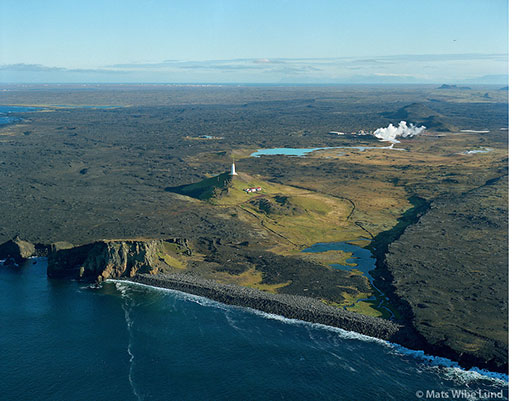 This day we will travel west and spend the entire day at the Reykjanes Peninsula, which is an UNESCO Global Geopark since 2015. The plate boundary at the Reykjanes Peninsula is dominated by oblique-rifting. Extension across the boundary gives rise to NE-SW tending normal faults and crater rows that can be tens of kilometers long. The transform component on the other hand results in short (few km) N-S trending strike-slip faulting as seen in the SISZ (on a larger scale).
 The Reykjanes Peninsula can be subdivided into six distinct volcanic systems. Periods of rifting of the volcanic systems and periods of seismic activity associated with the transform faulting alternate on a time scale of 600-800 years. At present, a seismic period is active. This was preceded by a period of volcanic activity lasting from the 8th or 9th century until the mid-13th century.
As opposed to the EVZ, volcanic systems at the Reykjanes Peninsula are characterized as being void of central volcanoes, magma chambers and calderas. The erupted products range from picritic to quartz tholeiitic. The landscape is low in relief compared to the central volcanoes of south Iceland, but dominated by hyaloclastic ridges that formed in sub-glacial eruptions. The Reykjanes peninsula also offers unique views of a large variety of volcanological features such as scoria and spatter craters, crater rows, tumuli (pressure ridges), pillow lavas and feeder dykes.